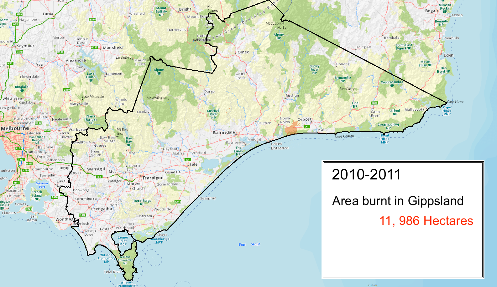
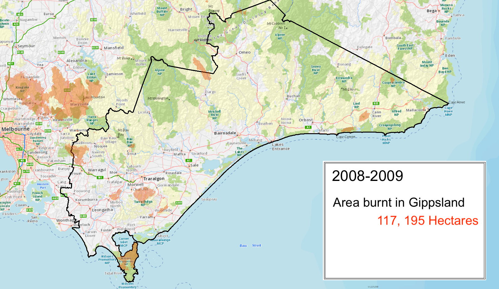
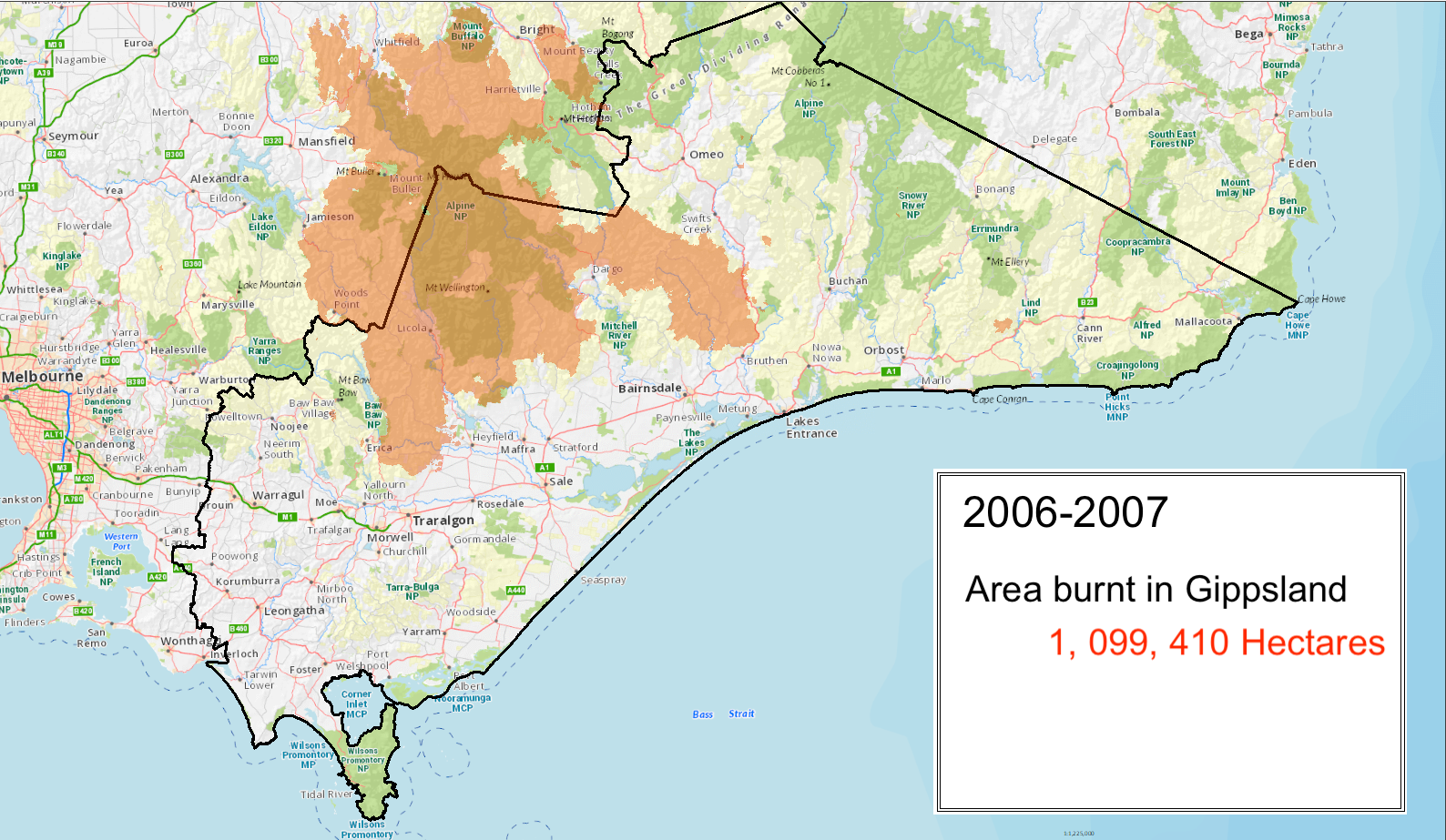
Bushfires in Gippsland
Agriculture was the initial driver of European settlement in Gippsland. Minor gold rushes followed in the 1850s and by the 1860s most of the region had been settled.
As the pioneers encroached further into Aboriginal territory, land use changed while declining Aboriginal populations meant the land was no longer being burnt in the traditional manner.
The presence of white settlers throughout the landscape meant the increased risk of house and life loss from bushfires. Although Gippsland wasn’t affected by the 1851 Black Thursday Fires, William Howitt’s recollections of how fires start and spread in Victoria are relevant to experiences here.
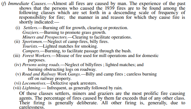
Most parts of Gippsland have experienced devastating fires throughout recorded history. While the nature of Gippsland’s weather patterns, terrain and vegetation make it one of the most fire prone areas in the world, a number of inquiries and inquests post fires indicate that deliberate or negligent use of fires (e.g. using fire to get ‘green pick’ or abandoned campfires) along with poor timber harvesting practices were the cause of many of these disasters.
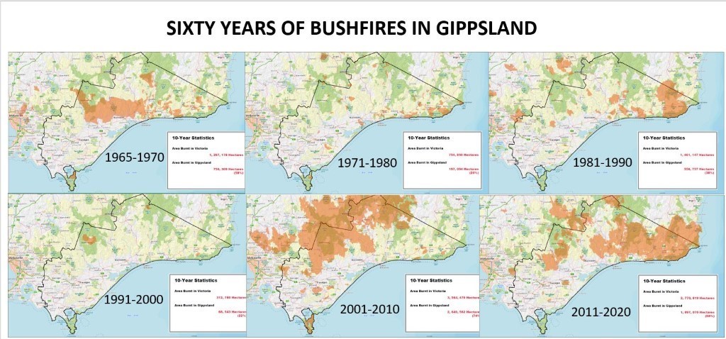
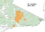
The following clip shows maps of significant fires in Gippsland since 1939:
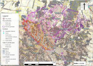
The following table summarises where significant bushfires have occurred in Gippsland since European settlement Click on each tab on the left hand side to see the corresponding fire season. Available maps are provided and in some instances you there are links to more information about the fires. If you have stories or photos to share about any of these (or other) fires please email them to us at cbushfireconnect@gmail.com.

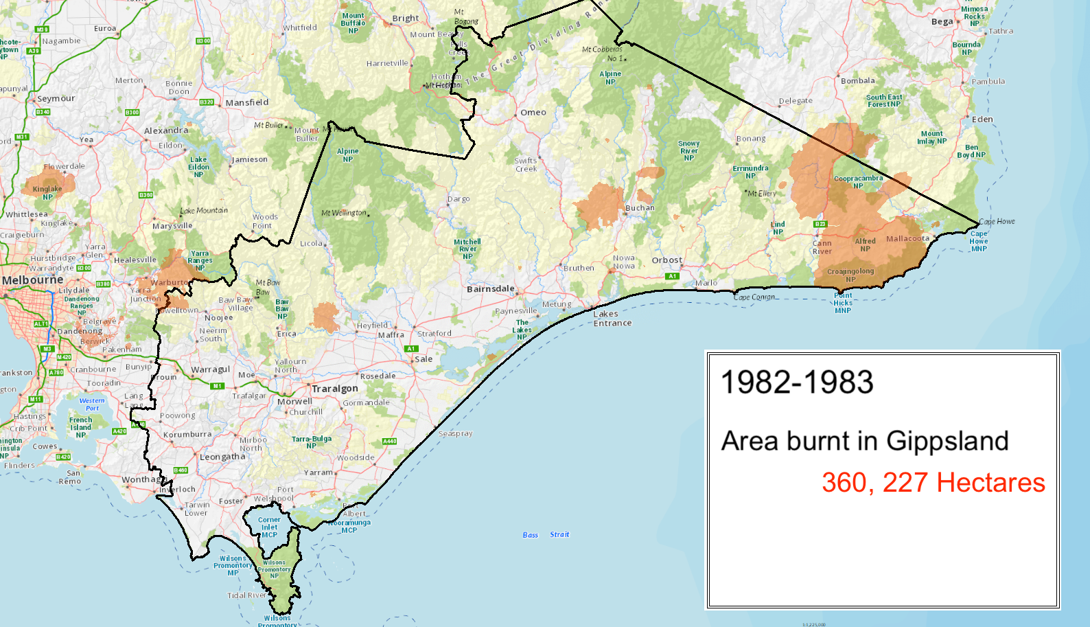
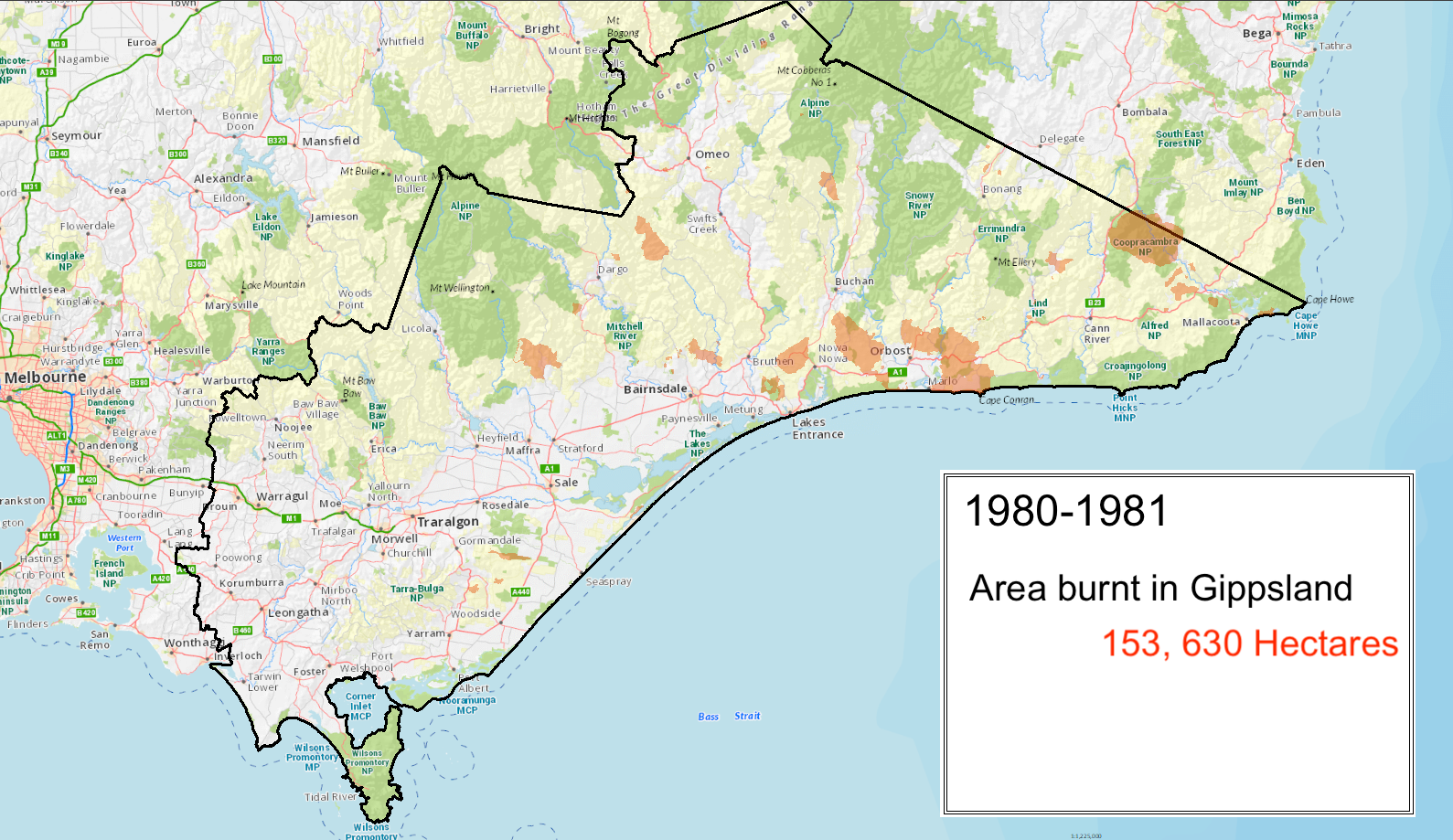
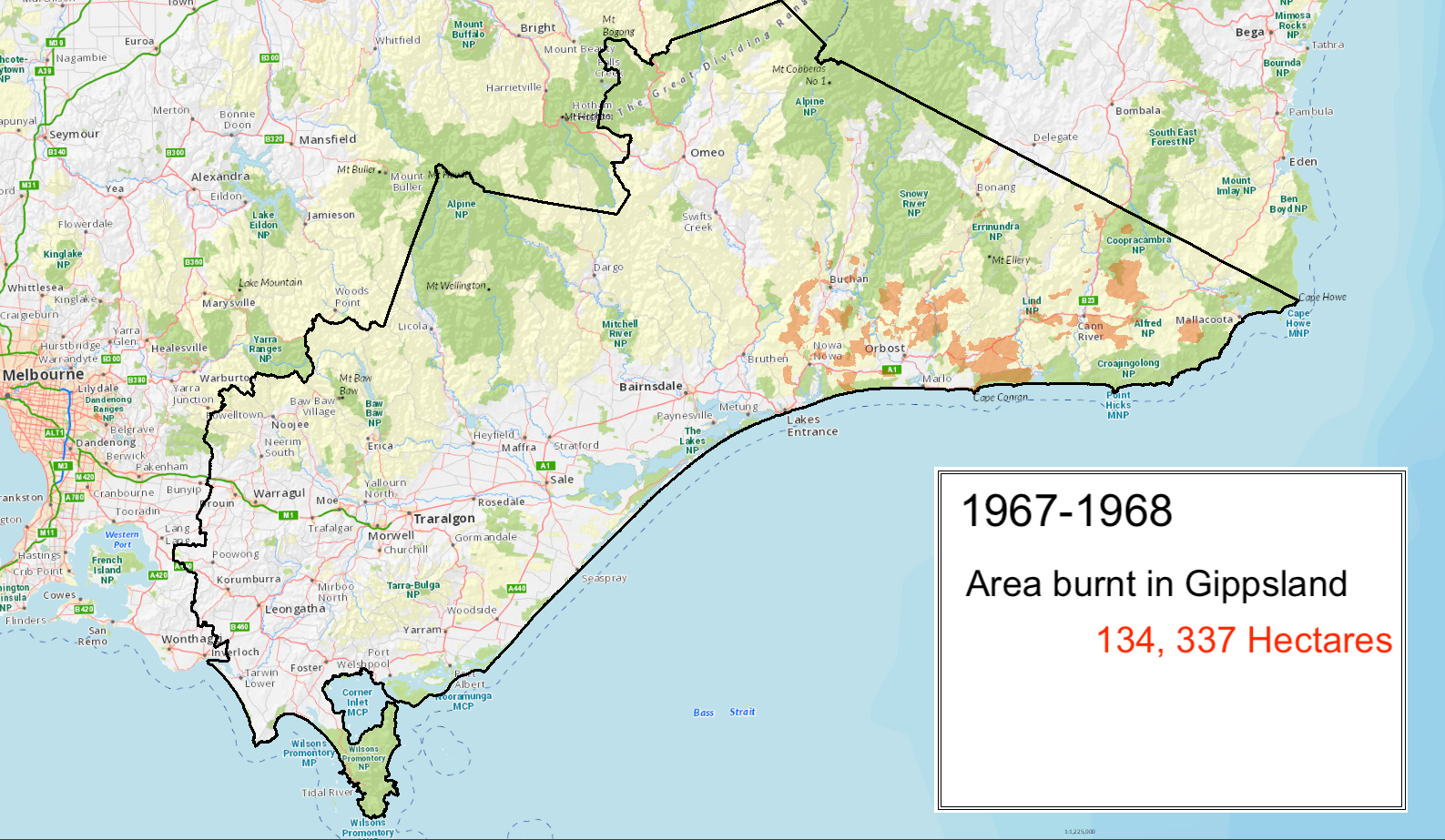
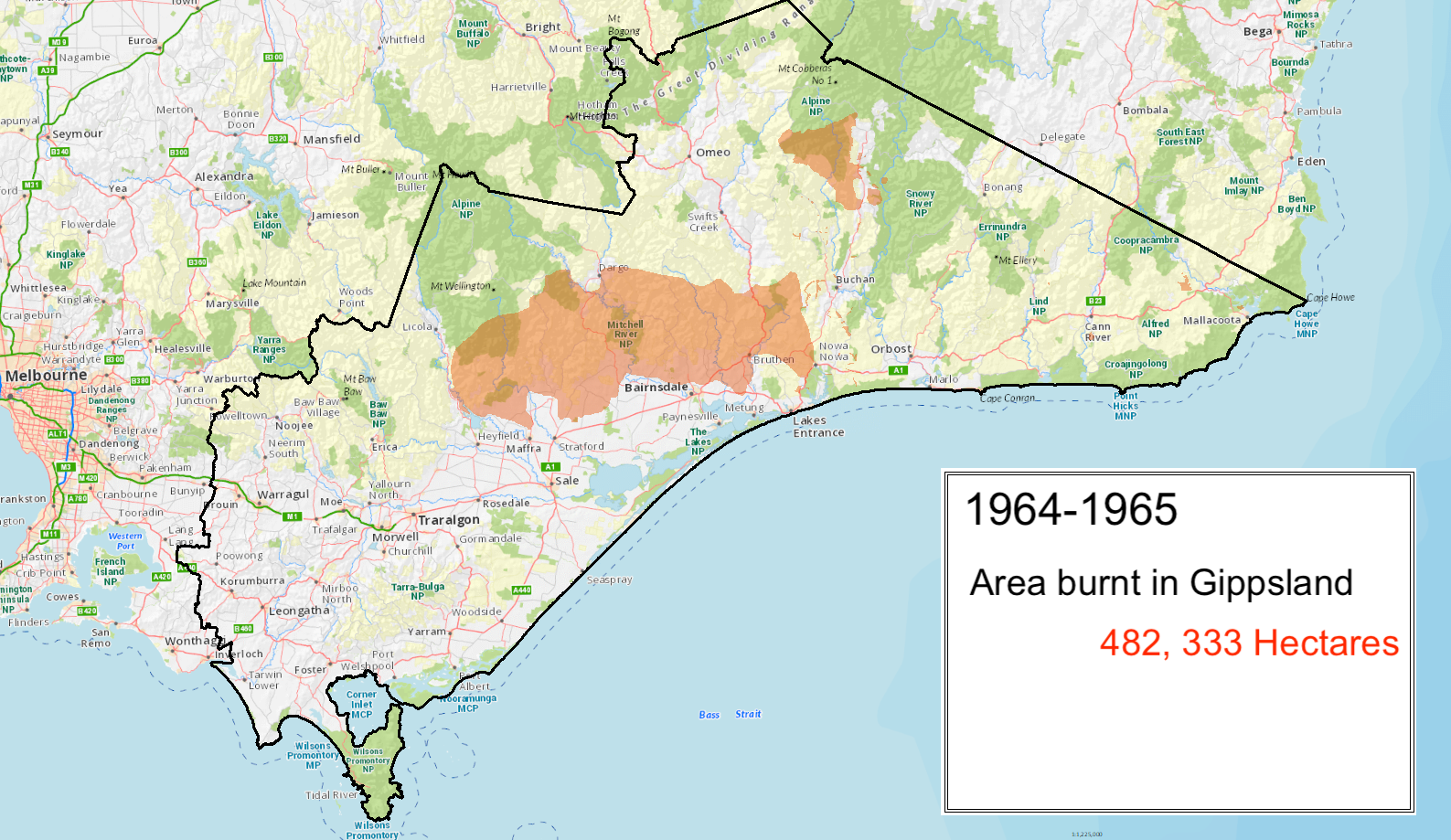
Parts of Gippsland affected:
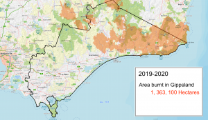
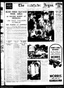
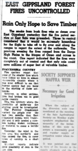
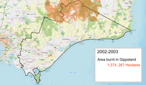
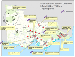
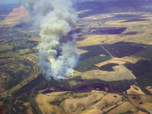
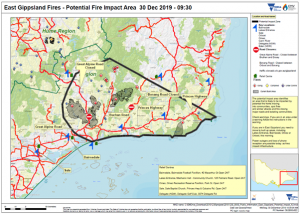
East Gippsland’s horror fire season arrived after an extended dry period lasting more than three years.
Lightning strikes on 21st November 2019 ignited a number of fires in the Buchan area
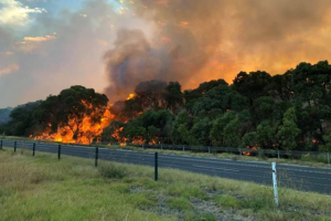
A state of emergency was declared on 2nd January with holiday makers and residents being urged to leave towns under threat.
By then fires had burnt more than 1.1 million hectares and led to the deaths of 4 people. Hundreds of people lost houses right across Gippsland with communities, with most of those losses occurring on 30 December when the communities of Clifton Creek, Sarsfield, Buchan and Mallacoota.
Widespread damage occurred to State Forests and National Parks and Reserves including the Buchan Caves Reserve and Croajingalong National Park and untold numbers of wildlife perished. Good rainfall in the area allowed the Tambo Complex fires to be declared ‘contained’ on 20 February but the Snowy Complex fires were not contained until 27 February.
Other information:
Parts of Gippsland affected:
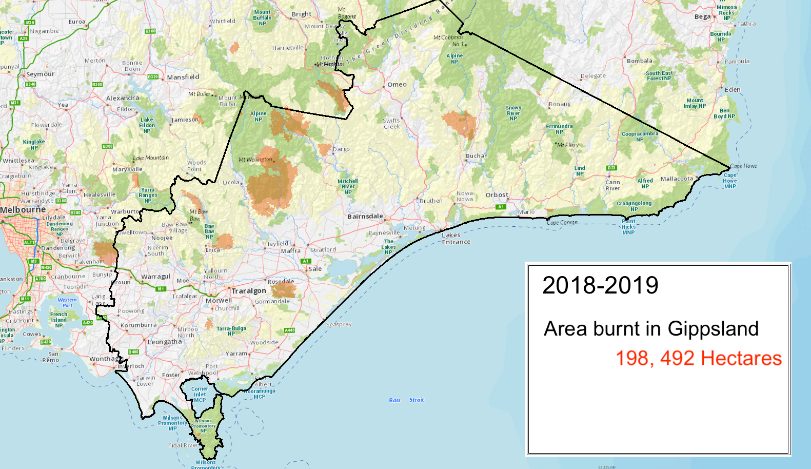
The summer of 18/19 was the hottest on record and many parts of Gippsland were in drought. On the 4th January 2019, fires started in the Holey Plains State Park near Rosedale and on 16th January at Timbarra near Gelantipy.
On the 25th, dry lightning strikes started the Thomson Catchment Complex that threatened Melbourne’s water catchments for many weeks. Fires also occurred near Grantville in Bass Coast Shire in early February and Walhalla in Baw Baw Shire. Bands of dry lightning on 28th February and 1st March lit several more fires including large ones that burnt significant amounts of park, forest and private land near Yinnar, Licola, Dargo and Dinner Plain.

Parts of Gippsland affected:
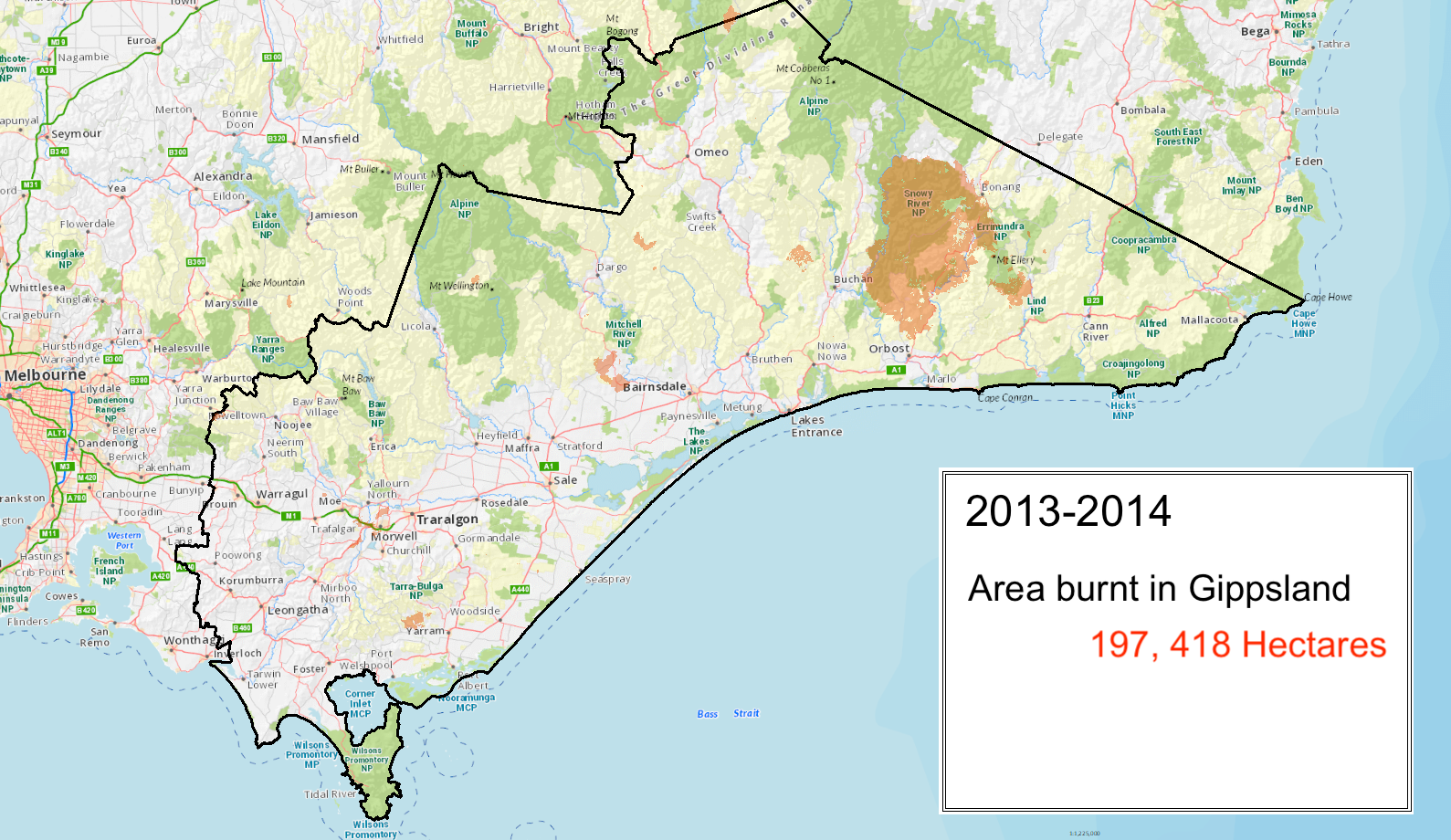
Drought conditions caused higher risk of fire spreading, Cabbage Tree Creek (718ha), Timbarra-Sunny Point (8,120ha – started in Sep 2017), Nov/Dec 2017 Cann River-Mueller’s Track (9,746ha) went for 25 days, Tamboritha-Dingo Hill Track (10,839ha – escaped campfire, burnt over part of 2007 bushfire area managed in area planned for autumn burning)
Parts of Gippsland affected:
Cabbage Tree Ck 718ha, March 2017 Crooked River – Wonnangatta Rd, 3,066ha, Castleburn 240ha
Parts of Gippsland affected:
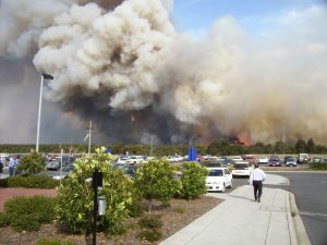
Many fires started in Gippsland following the heatwave of 13-17 January. These included the Hazelwood mine fire and fires at Mount Ray, Goongerah and Buchan.
The Hazelwood mine fire which started from embers spotting from the Hernes Oak and Driffield fires on Jan 17, ran for 45 days.
Extremely hot conditions on 8th and 8th Feb led to a massive spread including a trebling in size of the Goongerah-Deddick Track fires which burned for 70 days and covered 165,806ha. Other fires in Gippsland included Morwell (2,788ha), Jack River-Egans Road (2,864ha – started from a powerline) and the Mount Ray Fire which started on 16 Jan, moved a bit on a couple of hot days and then spotted through to Glenaladale on Sunday Feb 9, burning 6,727ha, most of it farmland.
Parts of Gippsland affected:
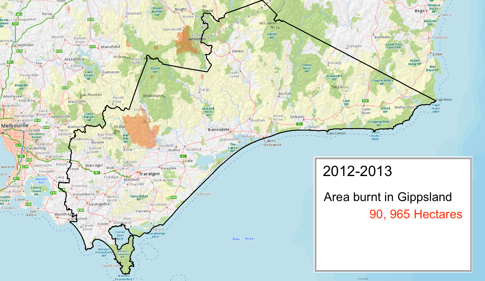
Victoria experienced a significant fire season in 2012–2013. Between December and mid-March more than 190,000 hectares of public and private land were burned.
A community member and four firefighters lost their lives, and 46 houses were destroyed.
Major fires included the Aberfeldy-Donnellys Creek, Harrietville, Chepstowe, and Grampians fires.
The Aberfeldy-Donnellys Creek fire was active for approximately six weeks from 17 Jan and burnt more than 86,000 hectares including many parts that had been lost in the 2007 Alpine fires.
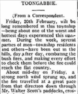
Communities of Glenmaggie, Licola, Coongulla, Cowwarr, Dawson, Heyfield, Seaton and Toongabbie were affected. One man died trying to flee in Seaton, 21 houses lost. The Dargo-Mathieson Track fire burnt over 10 days from 15 Feb 2013 and covered 1111ha. Smaller fires occurred in the Ensay North – Upper Little River Road area and East Caledonia – Howitt Track.
Parts of Gippsland affected:
The Tostaree Fire started 1 February on private land and spread through forested areas to reach a size 11,365ha.
The fire closed the Princes Hwy on the east for three days and caused many power outages. It was slowed and finally stopped on the eastern side by a 2010 fuel reduction burn and fuel reduction burns to the north and east slowed it sufficiently to stop it impacting on populated areas including Orbost.
Other information:
Parts of Gippsland affected:
Cann River 6,700ha, started on 17 Dec and did a lot of damage to regenerating forests
Parts of Gippsland affected:
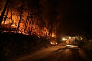
The Black Saturday bushfires were the worst in Australia’s history, killing 173 people.
Almost 80 communities were directly affected and entire towns were left unrecognisable.
The fires burned more than 2,000 properties and 61 businesses. Almost 430,000 hectares of land were directly affected, including 70 national parks and reserves and more than 3,550 agricultural facilities.
This included a fire that started at a hardwood plantation at Churchill and impacted the townships of Hazeldene, Koornalla, Callignee and Jeeralang. 11 people died and 145 homes were destroyed. (ADR knowledge hub)
Other fires that occurred in Gippsland that season included Delburn which started two weeks before Black Saturday destroyed 44 houses and burnt 6,534ha. Fires also occurred around Dargo (started on 6th Feb and burnt 13,640ha), Wilsons Promontory (started on 11th Feb and burnt 25,200ha) and Cann River (6,700ha).
Parts of Gippsland affected:
Cann River – Mueller Road fire started in Dec 2017 and burnt more than 9,000ha
Parts of Gippsland affected:
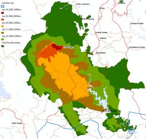
Fire agencies responded to more than 1,000 fires across Victoria from mid-December 2006 to mid-March 2007. The total area burned exceeded 1,200,000 hectares.
On 12 October 2006, a fire at the Morwell Open Cut coal mine did $30,000,000 damage.
On 14 Dec 2006 a fire was deliberately lit at Coopers Creek, east of Erica, that ended up burning 40,000 ha and lead to the death of one person.
The two most serious fires occurred in the north-east (the Great Divide North fire) and Gippsland (the Great Divide South fire). These fires were eventually contained in mid-February after burning for 59 days. The Great Divide North and South fires burned a total of 1,048,238 hectares, almost entirely on public land.
Other fires in Gippsland occurred at Seaton, Boulder Creek (near Cann River), Walhalla, Dargo, Mount Terrible near Jamieson, Gaffneys Creek, A1 Mine Settlement, Toongabbie and Seaton
Other information:

Parts of Gippsland affected:
Fires occurred in Baw Baw, South Gippsland Shires (Stradbroke grassfire – 500ha) and Latrobe (Moondarra – 15,200ha) .
The Moondarra fire was deliberately lit on January 19th. It threatened the settlements of Yallourn North, Willarua, Tyers, Tanjil, Moondarra, Erica and Rawson and was not bought under control until Feb 12 2006. In March 2002 the Granite Ck fire near Orbost burnt over 950ha).
Parts of Gippsland affected:
Wilsons prom had two distinct fires, burning more than 6,400ha in total.
Parts of Gippsland affected:
Blue Rock/Neerim fires burnt over 4,000ha

Parts of Gippsland affected:
Eight of these were unable to be contained and joined to form the largest fire in Victoria since the 1939 Black Friday bushfires.
Burning for 59 days before being contained, the Eastern Victorian (Alpine) fires burned more than 1.3 million hectares, destroyed 41 homes, more than 9,000 livestock and thousands of kilometres of fencing. 60% of the Alpine National Park was burnt.
Areas affected included Mt Buffalo, Bright, Dinner Plain, Benambra and Omeo. The fires cleared so much vegetation they provided the opportunity for archaeologists and traditional owners to rediscover much about Aboriginal occupation and use of the Alps prior to European occupation.
Other information:

Parts of Gippsland affected:
The Caledonia fire in the Alpine National Park was reported on New Year’s Eve, 1997 and burned 34,100 hectares over10 days. Of this area, 22,000 hectares was in the Alpine National Park and 10,000 hectares was in the Carey River State Forest. The suspected cause was a campfire.
Fire also burnt more than 3,700ha in the Croajingalong National Park
Parts of Gippsland affected:
Five major fires broke out, including fires in the Dandenong Ranges that took three lives, destroyed 41 houses and burned 400 hectares. Other areas affected included Arthurs Seat, Eildon State Park, Gippsland and Creswick.
Parts of Gippsland affected:
Large fire at Tubbut (9,000ha)
Parts of Gippsland affected:
Orbost 1,000ha
Parts of Gippsland affected:
Fires occurred in Cann River, and Wilson’s Prom.
Parts of Gippsland affected:
Ash Wednesday was Australia’s best-known bushfire event, at least until Black Saturday 2009. More than 100 fires were burning already by 16 Feb but the situation exploded after 2pm when the fires formed several complexes.
On the day 210,000 hectares burnt and killed 47 people. More than 27,000 stock and 2,000 houses were lost.
The same season fires in the Cann River forest 120,000ha from 31 Jan -12 Feb and 120,000ha from 4-12 Mar. 33,000ha were also burnt around Mt Elizabeth near Bruthen.
Parts of Gippsland affected:
East Gippsland, Maffra 12,100, Swifts Ck 9,500, Orbost 32,700, Nowa Nowa 28,000, Colquhoun 6,600, Cann River 27,400
Parts of Gippsland affected:
Tamboon (7,400ha), Mallacoota (29,900ha)

Parts of Gippsland affected:
On 15 January a wheel and axel falling off a trailer generated sparks that caused a deadly fire. Two people died, 1 house and 36 buildings were destroyed and more 6,500 were killed. The fire burnt to the Banksia Peninsula. Other fires that year occurred in the Mitchell River NP (2,900ha), Toongabbie (1,600ha) and Stratford (550ha).
Parts of Gippsland affected:
Wilsons Prom 2,500ha + 400ha
Parts of Gippsland affected:
Wilsons Prom 1,900ha
Parts of Gippsland affected:
Large fires at Wentworth River – Dargo (6,000ha) and Cann River, Nowa Nowa and Orbost (11,900) Wilsons Prom (1,200ha), Mallacoota (5,200ha).
Parts of Gippsland affected:
Nowa Nowa (2,500ha) and Wilsons Prom (320ha).
Parts of Gippsland affected:
Wilsons Prom (320ha)
Parts of Gippsland affected:
Fires at Bonang burnt 16,000ha, destroyed 3 houses and 20,000 stock (It was a devastating year for fires with 28 people losing their lives, including 19 at Lara, near Geelong. No fires occurred due to grazing interests.)
Parts of Gippsland affected:
Major forest fires >1000ha occurred in East Gippsland and Baw Baw Shires. Some areas were impacted by multiple fires. Cann River (8,000ha + 13,000ha), Orbost, (23,000ha+5,000ha+7,000ha+8,000ha+5,000ha), Nowa Nowa (8,000ha+3,000ha) and Neerim (5,000ha).
Parts of Gippsland affected:
Fires in Gippsland burned for 17 days, covering 300,000 hectares of forest and 15,000 hectares of grassland. More than 60 buildings and 4,000 stock were destroyed. (Escaped March 3, blow up day March 6 (RE says 3 deaths)
Feb 22 – 28 57,000 ha Omeo
Feb 22 – 28 Briagolong, Glenmaggie and Omeo fires escaped on Mar 3 and severe weather on that day plus Mar 6 saw them grow to 304,000 ha.
Fires also occurred at Cann River, Club Terrace, Genoa and Combienbar
Other information:
Parts of Gippsland affected:
Yarram (8000ha) and Orbost (3,600ha)
Parts of Gippsland affected:
Wilson’s Prom (20,400ha), Lake Tarli Karng (3,850ha), Cromwells Knob (5,200)
Parts of Gippsland affected:
Grass fires > 4000ha at Morwell
Parts of Gippsland affected:
Major forest fires Mt Cann (45,493ha), Snowy River East (15,350ha)
Parts of Gippsland affected:
Briagolong 2,500ha
Parts of Gippsland affected:
The Argus reported this season saw the worst fires across state in 10 years although most were in the west, fire was also reported at Bairnsdale. The CSIRO re-released its 1944 study in to cause of house loss from bushfires – the first of its type – that stressed the importance of protecting against ember entry and keeping flames away from walls.
Parts of Gippsland affected:
Major fires >1000ha at Cann River and Orbost (40,000ha)
Parts of Gippsland affected:
A fire that originated on the Hume Highway near Benalla burned about 100,000 hectares and killed several people.
Major fires burnt over 412,400 ha crown land that year. One third of that was at Bemm River, Deddick River and Wentworth River. Other major forest fires were at Cabbage Tree (29,650ha), Snowy River (west) (80,400ha), the Cobberas (38,093ha), Wentworth Dargo (45,600ha), Nicholson River (3,000ha), and Wonnangatta (1,175ha).
Parts of Gippsland affected:
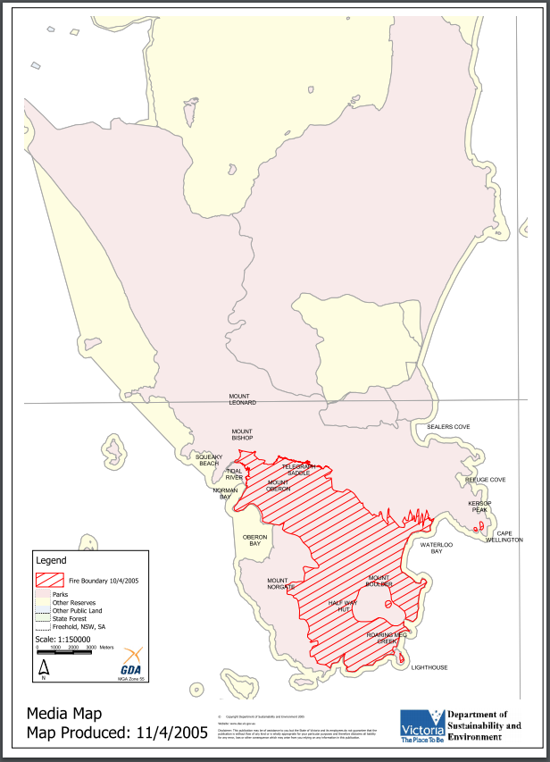
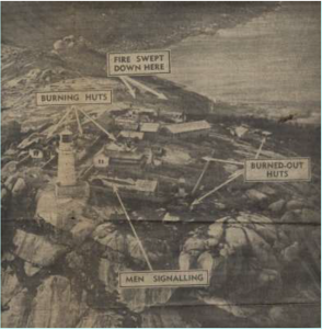
Wilson’s Prom fires covered 36,450 ha and on 14th Feb 1951 destroyed the lighthouse.
Fires also occurred at Poowong in South Gippsland, Tambo Crossing in East Gippsland
Parts of Gippsland affected:
Fires >1000ha at Briagolong
Parts of Gippsland affected:
Fires burnt near Morwell and Yallourn (14 Jan – 14 Feb) where it was reported that 13 people died and 200 houses were destroyed, along with another 80 at Morwell and 40 at Traralgon, 4,000 sheep burnt at Sale.
Major forest fires > 1000 ha were at Cabbage Tree to Bemm River (19,000 ha), Orbost (25,900ha), Cobbannah (24,300ha), Traralgon (40,400ha), Yarram (7,700ha), Boolarra (4,800ha) and Binginwarri (4,700ha)
Other information:
Parts of Gippsland affected:
Fires in South Gippsland killed one person at Foster and another at Hedley, destroyed several houses including 19 in Yarram, where fires burnt on a 60 mile front.
Parts of Gippsland affected:
Colquhoun to Lakes Entrance on the 4th and Nungurner (1,000ac) on the 5th Jan, Tanjil Bren in Feb and Mar, Heyfield in March

Parts of Gippsland affected:
Fires raging across Victoria from December 1938 to January 1939 peaked on Friday 13 January – Black Friday. Earlier, in October 1938, there were fires in Erica, Currajong and Noojee, then in December in Bairnsdale and Valencia Creek. The blow-up days were Jan 8, 10 and 13. On January 8th 12 people died at Erica, timber mills and many houses were burnt and Yallourn was ringed with fire. On 13th January Noojee was gutted except for the pub Wilson’s Prom was ablaze from the neck to the lighthouse. On January 14th Omeo was attacked with the hospital, 4 shops the hotel and 27 houses destroyed. One man died at Cobungra station and fires swept through Hotham Heights with the manager and his family taking refuge in a well. According to one report house losses at Noojee were 45, at Omeo, 40 and at Erica, 16.
Walhalla was threatened, a home on the outskirts was burnt and the hospital was evacuated.
Eight people were killed in a fire at Tanjil Bren, and six people were seriously burned at Jumbuk with another 11 narrowly escaping death by suffocation. Wilsons Prom was devastated and all animals in the game reserve killed. A Jeeralang family of six suffered severe burns when their car overturned as they were trying to escape the fires.
Fires flared up again on February 13th and were reported in Athlone, Poowong North and Drouin and Ensay North.
All up, the fires burned 1.5 to 2 million hectares, including 800,000 hectares of protected forest, 600,000 hectares of reserved forest and 4,000 hectares of plantations. They killed 71 people and destroyed more than 650 buildings and the township of Narbethong (except for the pub). The fires affected almost every section of Victoria. Areas hardest hit included Noojee, Woods Point, Omeo, Warrandyte and Yarra Glen.
Other information:
Nearly two million hectares of the State burned on Black Friday 1939
The 1939 Royal Commission in to the fires concluded that ‘These fires were lit by the hand of man’ Commissioner Stretton found that a combination of dry weather, deteriorated condition of the forests due to poor land use practices, inadequate laws, along with deliberate or negligent misuse of fire were the cause of the fires and made many recommendations to prevent future conflagrations.
Parts of Gippsland affected:
Fires from Brodribb to Club Terrace
Parts of Gippsland affected:
Fires everywhere in March 1936 with Sale, in Gippsland, among the worst
Parts of Gippsland affected:
In October 1933 Erica was reported to be surrounded by fire with many mills threatened
Parts of Gippsland affected:
In January private property burnt at Omeo and in March Glen Wills was threatened by fire
Parts of Gippsland affected:
Major fires occurred in many districts across Victoria throughout the summer. Fires burnt in Trafalgar and forests near Bairnsdale for several days in January. Large areas of state forest in Gippsland were burned and nine lives were lost. By the 5th February 1932 fires spread from Warburton to North Gippsland.The settlements of Yarra Junction, Powellton (1 death) were destroyed, Fires occurred at Noojee, Erica (6 died) and Warragul (2 firefighters died)
Parts of Gippsland affected:
Fires at Wonthaggi, Koowerup, Foster, Haunted Hills at Yallourn, Trafalgar
Parts of Gippsland affected:
“The careless weekend allotment holder burning off his rubbish before returning to the city is a menace to the forests. But the greatest menace of all is the selfish grazier wilfully set the mountains ablaze to provide grass for his cattle. There were graziers who assist the department, but many were enemies to the community and did their work with little fear of detection. Hostility to fire prevention remains strong in the eastern part of Gippsland where people who own or lease land for grazing have a long tradition of burning for grass growth.”
Parts of Gippsland affected:
156,000 acres burned between Bairnsdale and Cann River, In January there was a fierce fire at Yallourn old coal cut, major blaze at Orbost destroyed 7 homes while one near Sale killed 300 sheep
Parts of Gippsland affected:
Fires burnt 11,282ac bush at Mallacoota
Parts of Gippsland affected:
Forest fires burned across large areas of Gippsland throughout February and into early March. Many lives were lost in addition to widespread damage to farms, homes and forests. In January fires occurred at Leongatha, Wonthaggi and Foster.
The fires came to a head on 14 February, with 31 deaths recorded at Warburton, 4 at Noojee and 3 at Erica. Other areas affected included Noojee, Kinglake, Erica and the Dandenong Ranges. At Tynong fires – with flames 30 foot high were caused by someone smoking out a rabbit. In February, a new coal face ignited at Yallourn causing 35,000 pounds worth of damage. By the 10th March bushfires were within quarter of a mile of Wonthaggi post office and there was a large fire at Foster North. The counties of Tambo, Croajingalong, Benambra and Tanjil were affected. Grazing interests were said to have caused 37% of the fires.
Parts of Gippsland affected:
Fires in Crown Land at Mallacoota
Parts of Gippsland affected:
Fires covered most of County of Croajingalong (land east of the Snowy River).
Parts of Gippsland affected:
In January fires affected Rosedale, Heyfield, Glengarry and forest at Orbost and in March Traralgon, Toora, Sale and Longford
Parts of Gippsland affected:
Fires at Maffra and Rosedale
Parts of Gippsland affected:
Fires burnt 1900ac at Nowa Nowa and 11,000 ac at Neerim
Parts of Gippsland affected:
Fires at Moe in February when temperature reached 103 degrees
Parts of Gippsland affected:
Serious fires at Bairnsdale, fires raging at Toora, and south of Traralgon (including Callignee), west of Cowwarr and Toongabbie, (Mention that land around Warragul was cleared after the 1900 fires), fires raged through Drouin but the damage was mainly to grass and fences, Warragul and Rosedale enveloped in smoke, in March flames 4 miles wide threatened Mirboo North.
Parts of Gippsland affected:
Serious fires in Gippsland cause a lot of damage with flames 1.5mile wide. Areas affected included 20,000 acres in the headwaters of the Thomson, Avon, Macalister, Mitchell and in Croajingalong. There were disastrous fires in Briagolong district, Woolenook and Wilson’s Promontory.
Parts of Gippsland affected:
Fires in Bairnsdale on Feb 2
Parts of Gippsland affected:
Fires at Toora in February
Parts of Gippsland affected:
Fires at Bruthen
Parts of Gippsland affected:
Fire in Warragul, Traralgon and Moe
Parts of Gippsland affected:
Destructive and widespread fires are reported to have occurred in 1905 and 1906 – and fires extended from Gippsland to the Grampians in 1912. Fires in South Gippsland and across Gippsland till rains came at end March. At Mount Best, near Foster, 6 children from one family died of suffocation while fleeing their house, and at least another 7 died in Toora and Foster. 100 foot high flames were reported at Welshpool and Agnes. A Mr Vale, a school teacher at Mount Best saved his 28 students by evacuating them and placing them under wet blankets and rushing through the flames to get them water. Hundreds were left homeless between Foster and Welshpool.
Fires at Walhalla destroyed a lot of timber and the huts of wood splitters.
Parts of Gippsland affected:
Fires were reported in Bairnsdale in December and in Morwell in January and February
Parts of Gippsland affected:
Fires at Neerim North destroyed properties and homes. Reference was made elsewhere to fires Warragul in 1901 that destroyed much of the timber around the area, but that led to land being cleared and successfully set up for grazing/pasture
Parts of Gippsland affected:
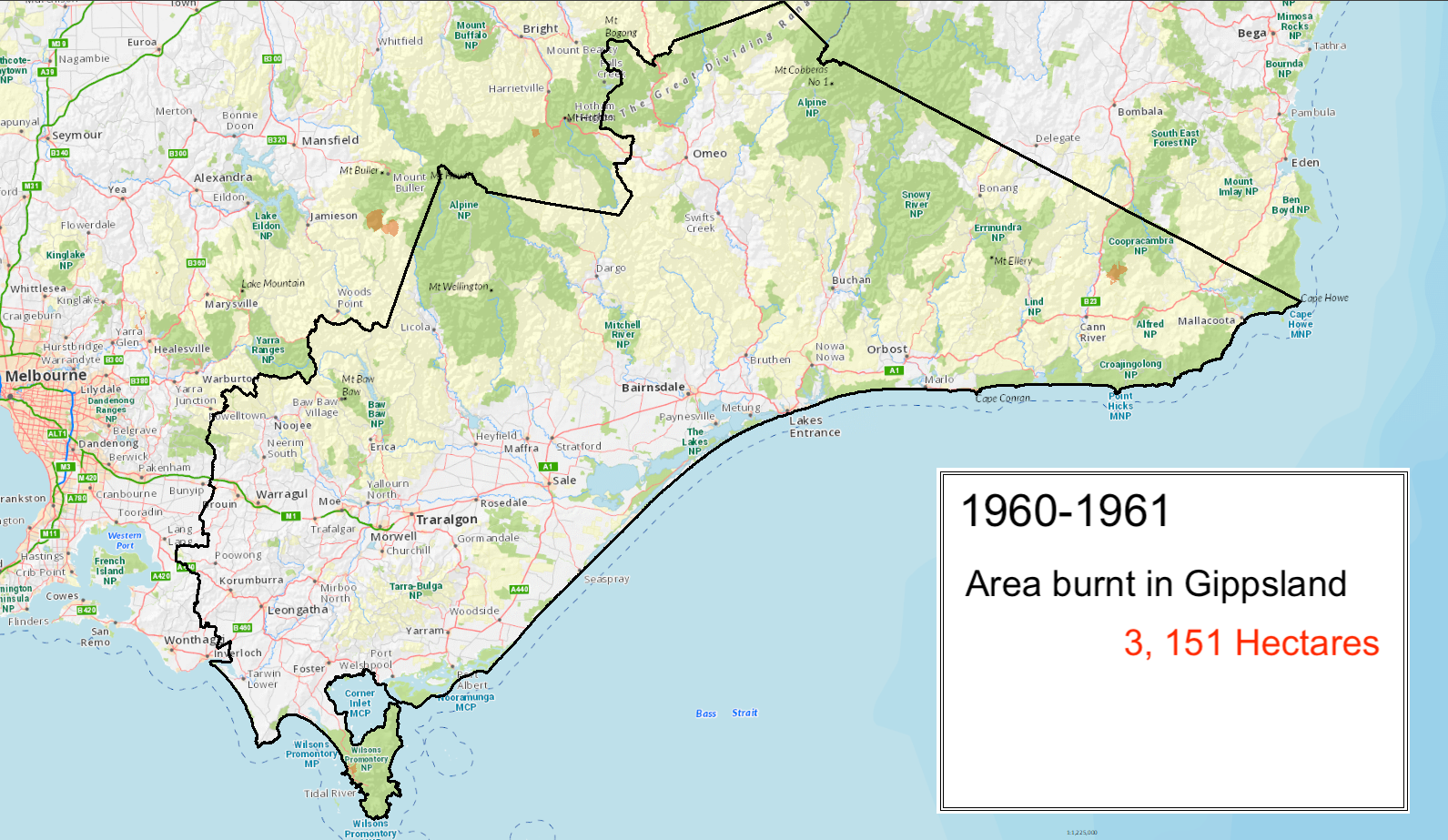
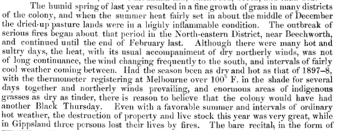
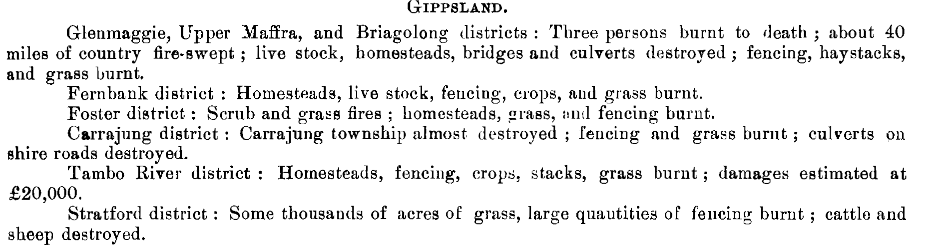
In December 1899 fires were burning in Heyfield and Bairnsdale district from Forge Creek to Paynesville where private grazing lands and forest reserves were lost. In the last week of February fires occurred in Glenmaggie, Upper Maffra, Briagolong, Fernbank, Foster, Carrajung, Tambo River districts and Stratford.
The 1900 Royal Commission into the devastating fires across the state said the four main causes were sparks from railway locomotives, phosphorised bait used for rabbits, using fire to clear land and reckless use of campfires. The commission recommended a 10 foot cleared radius around campfires and extinguishment before leaving as well as 10m firebreaks between private property and crown land and along railway lines and fire restrictions between December and March.
Other information:
Parts of Gippsland affected:
In December 1898 disastrous fires occurred at Bruthen. Fires were also reported in January 1899 at fires Briagolong
Parts of Gippsland affected:
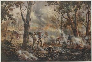
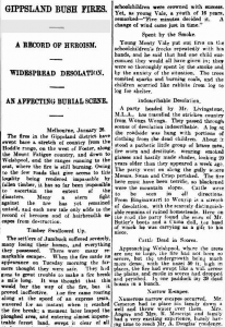
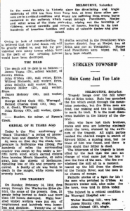
This was one of the worst bushfire seasons on record, with fires across the state but the worst on Red Tuesday in West and South Gippsland. Fires began in Warragul and Traralgon on 31 Dec 1897, 2,000 buildings were destroyed in South Gippsland and 12 people lost their lives.
From January to February extensive tracts of country in central and west Gippsland (Neerim North, Thorpdale, Neerim, Poowong, Warragul, Strzelecki, Won Wron, Yarram (with flames a mile wide at the south end of the town), Devon, Leongatha, Korrumburra, Morwell, Stratford, Traralgon, Port Albert, Mirboo North, Grantville, Sale, Jeetho, Drouin and Lakes Entrance and Foster were devastated.
Other information:

Parts of Gippsland affected:
Fires were at Neerim South in December and Neerim and Korumburra in January 1897.
Parts of Gippsland affected:
Fires in Foster
Parts of Gippsland affected:
Fire in Yarram deliberately lit and destroyed a hay shed. In February 1893 Korumburra was saved by a change of wind directions and destructive fires were reported in Drouin, Foster, Kooweerup, Moe, Port Albert, Rosedale and Sale.
Other information:
Argus Mon 13 Feb 1893 page 6 – Disastrous bushfires in Victoria
Parts of Gippsland affected:
Large fires in Omeo on the Gibbo Road – the main route to Wodonga. The third Omeo Golden Age Hotel was destroyed by fire in 1891.
Parts of Gippsland affected:
In February 1885 fires at Walhalla destroyed a gold battery, and four steam sawmills as well as parts of the Long Tunnel tramway
Parts of Gippsland affected:
Bushfires raged in Port Albert and Won Wron


2 Comments
good job relly helped me on my project
We’re really pleased you found the site useful.